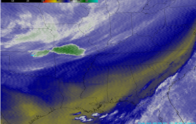
Above is a recent water vapor satellite image of the lower 48 United States. I'm sure your attention is immediately drawn to the right hand side of the image which is "blank" insofar as cloud cover (or moisture in the clouds) is concerned. That's not a simple software glitch, as one of the GOES Weather Satellites used to produce the full image, GOES-13 or "GOES East" is out of service.
The problem began a few days ago when images from the GOES East satellite started to become "noisy", as shown in the comparison below:
"Noisy" GOES East Image from 9-21-12
What the Image Should Look Like
The problem worsened on Sunday night, and the unit was taken completely out of service early yesterday.
The fact that the satellite orbits the earth at an altitude of 22,300 miles above the surface makes fixing it very difficult, to say the least. Engineers on the ground are attempting to "remotely" fix the problem, but if they can't, then the satellite will likely be taken out of service permanently.
In the meantime, NOAA has repositioned a "standby" satellite, GOES 14, and it is now generating the images that GOES East used to be responsible for. Many satellite imagery display systems, such as the one shown in the image at the top of the post, will have to be reprogrammed in order to display the images from the "new" satellite.
Thankfully, there were no significant tropical systems taking place in the Atlantic during the outage, or our observational abilities would have obviously been severely hampered.
For more information from 'The Original Weather Blog', including shorter, more frequent posts during rapidly changing weather events, please be sure to follow Rob on facebook and twitter:
If you are in need of customized, site specific weather forecasts or storm warnings for your company or event, be sure visit Rob's professional webpage at WeatherGuidance.com.


0 comments:
Post a Comment