


Wednesday, 31 October 2012

When you're one of the estimated 5.3 million people that ride the New York City area subway system every day, what do you do when its under water (literally) and out of service? If you have one, you jump in the car or on your scooter or motorcycle, right?
That's exactly what thousands did today, and it caused a huge problem as the unusually high number of vehicles jammed roadways, some of which were still closed and/or covered with some kind of debris. The result: a traffic jam to end all traffic jams.
In a press briefing this afternoon, Mayor Michael Bloomberg ordered that, effective tomorrow, only "high occupancy" vehicles will be allowed into Manhattan during the hours of 6 a.m. to Midnight. This order will last through Friday, at least as of now. A "high occupancy vehicle" is defined as one that contains 3 or more people.

This announcement will undoubtedly add frustration for those already unable to get to and from work and other necessary destinations. Bloomberg tried to make clear that this is a necessary evil until the crippled subway system can be put back into service. As he put it "the roadways were designed to handle only so much traffic..."
Exactly when the mass transit system will be completely up and running again remains to be seen. Officials seem to be trying to put a positive "spin" on the situation, which could be expected I suppose, but the ugly truth of the matter is that we're most likely a long way from seeing the subway system fully operational again.
Seven major subway tunnels under the East river remain flooded, most of them in Lower Manhattan (see New York Times map below):

City and contracted crews are trying their best to pump hundreds of thousands of gallons of water out of the system so that engineers and inspectors can get inside and inspect the extent of the damage.

The fear is that critical equipment was either heavily damaged or destroyed by corrosive salt water that flowed into the system on Monday evening. We won't know how long repairs will take until the water is pumped out and the inspections are complete.
To further complicate matters, some other elements are beyond the control of the city at this point, such as just when electrical power (which supplies energy to the subway system as well as its lights, signals, etc.) will be fully restored as well.
The city also points out that it's not like one segment of the subway can be reopened as soon as its fixed. It depends on how that segment interacts with other segments along the routes. This complication is kind of like one key airport being shut down during a snow storm. That affect "snowballs", resulting in delays and/or cancellations across the remainder of the system.

The economic impact on not only the city but the region and the entire country is huge. Every hour that companies are down because they have no staff or are under staffed potentially costs millions of dollars in productivity and sales. A study performed last year by the New York State Energy Research and Development Authority concluded that a flood very similar to the one that occurred on Monday night would result in $10 billion in direct damages to the transportation system, and $40 billion in economic losses due to lost productivity and sales.
Clearly, there are two key elements to getting New York City back on its feet at this point: (1). getting the power back on and (2). getting the subways running again. You can bet that officials are working double and triple time to get this done as soon as possible. The stakes are simply too high not to.
Many people from around the world are visiting this blog to follow the aftermath of Hurricane Sandy. Welcome visitors! Please be sure to check the homepage of the blog and refresh there for all of the latest posts...
For more information from 'The Original Weather Blog', including shorter, more frequent posts during rapidly changing weather events, please be sure to follow Rob on facebook and twitter:


If you are in need of highly customized, site specific weather forecasts and/or storm warnings for your business, school or event, be sure visit my professional webpage at WeatherGuidance.com.

As city crews pump water out of the subways and tunnels across NYC for a 2nd straight day, many residents will still find themselves without power for this Halloween.
As of 7am EDT this morning, 1.8 million customers were still without power in New York, with a staggering 70% of Long Island still in the dark. In New Jersey, 86 percent of the region serviced by New Jersey Power & Light is without power.
Little has changed since this map was produced by the New York Times yesterday evening, to give you an idea as to the overall area covered by power outages. It is estimated that 7 to 7.5 million are still without power this morning:

Yesterday we heard of several municipalities considering "cancelling" or postponing halloween, but I haven't seen anything in black and white this morning saying that any such decisions were made.
It will obviously be a lot more hazardous than normal to go trick-or-treating across the region this evening, so if you plan on going out, be sure to use extreme caution. Keep in mind that a lot of street lights and traffic / pedestrian signals will not be working. Try to wear some sort of reflective clothing and carry flashlights to both light your path and to allow others to see you.
Many people from around the world are visiting this blog to follow the aftermath of Hurricane Sandy. Welcome visitors! Please be sure to check the homepage of the blog and refresh there for all of the latest posts...
For more information from 'The Original Weather Blog', including shorter, more frequent posts during rapidly changing weather events, please be sure to follow Rob on facebook and twitter:
If you are in need of highly customized, site specific weather forecasts and/or storm warnings for your business, school or event, be sure visit my professional webpage at WeatherGuidance.com.
Tuesday, 30 October 2012

The above image was taken in lower Manhattan as Hurricane Sandy struck yesterday evening, right? Wrong. Believe it or not, this shot was taken along Lakeshore Drive in Chicago earlier today, as high wave action pounded the area along southern Lake Michigan.
A peak wave height of 21.7 feet was measured at the South Buoy on Lake Michigan at 12 Noon today. The timing of the massive wave corresponded perfectly with a peak wind gust of 56 mph, as indicated by the red plot on the graph below:

This set a new record for the 2nd highest wave at that location. The highest wave ever recorded at that point on Lake Michigan was 22.9 feet, set on September 30, 2011.
It is fairly unusual for the remnants of a tropical cyclone to cause high wave action on Lake Michigan. Most of the high waves on the historical record in this region are caused by deep low pressure systems that form during the fall and winter.
This is just further illustration that the effects of Hurricane Sandy, and now the remnants thereof, are widespread and far reaching. Take a look at this recent visible satellite image:

The cloud pattern associated with the remnants of Hurricane Sandy spans over 1400 miles at this hour!
Just another reason why I believe Hurricane Sandy will go down in the record books as the "storm of a lifetime" for most of the people reading this blog (including myself).
Many people from around the world are visiting this blog to follow the aftermath of Hurricane Sandy. Welcome visitors! Please be sure to check the homepage of the blog and refresh there for all of the latest posts...
For more information from 'The Original Weather Blog', including shorter, more frequent posts during rapidly changing weather events, please be sure to follow Rob on facebook and twitter:
If you are in need of highly customized, site specific weather forecasts and/or storm warnings for your business, school or event, be sure visit my professional webpage at WeatherGuidance.com.

By now you've probably heard of the record tide gauge reading yesterday evening at The Battery near Lower Manhattan. The water level at high tide reached an astounding 13.85 feet (see the solid red line on the tide graph below), crushing the old record of 11.2 feet set way back in 1821.

The solid red line running left to right across the same graph denotes the flood level of 6.5 feet at that location. (I've noted that in purple text for your reference).
Note that while the water level at high tide this morning did briefly exceed 6.5 feet (yellow circle on the identical graph below), the forecast (black lines and "x"'s on the same image) calls for levels to remain below flood stage at both high tide this evening and again tomorrow morning (although it will come very close to 6.5 feet at that time):

That is certainly good news in that additional seawater should not be added to the already bad situation across the region.
The bad news is that much water still remains. While the water at ground level will continue to gradually recede over the next few days, much water will have to pumped out of subway tunnels, underpasses, parking garages and other below ground infrastructure across the city.
Until the water is pumped out of the subway system, the true extent of the damage won't be known, and a plan of action for repairs cannot be developed and carried out.
Our thoughts and prayers will certainly remain with the folks across the Northeast who are only just beginning to pick up the pieces after Hurricane Sandy.
If you would like to help the folks in this region and are unable to do so physically, please consider making a donation to the American Red Cross or another reputable charity.
Many people from around the world are visiting this blog to follow the aftermath of Hurricane Sandy. Welcome visitors! Please be sure to check the homepage of the blog and refresh there for all of the latest posts...
For more information from 'The Original Weather Blog', including shorter, more frequent posts during rapidly changing weather events, please be sure to follow Rob on facebook and twitter:
If you are in need of highly customized, site specific weather forecasts and/or storm warnings for your business, school or event, be sure visit my professional webpage at WeatherGuidance.com.

Water Rushes into the Carey Tunnel in NYC Yesterday Evening (Getty Images)
The death toll from Hurricane Sandy's impact on New York City's 5 boroughs has risen to 10 as of this writing:
- A 30 year old man in Flushing, Queens died when a tree crashed through his home
- A 23 year old woman in South Richmond Hill, Queens, was electrocuted when she stepped into a puddle draped by a live wire
- A 70 year old woman was found in a flooded home on 98th Street in Queens
- An off-duty NYPD officer drowned in Staten Island while trying to reach loved ones who had taken shelter in the attic of their flooded home
- A 13 year old girl was found dead on a lawn on Staten Island
- A 55 year old man was found dead inside a business on Broad Street early this morning. NYPD believes his body floated into the building from the outside
- A 75 year old woman died in her Gramercy Park home when her respirator stopped after the electricity went out
- A man and a woman, both 24 years old, were killed in Brooklyn by a falling tree near Ditmas Avenue and E. 18th Street
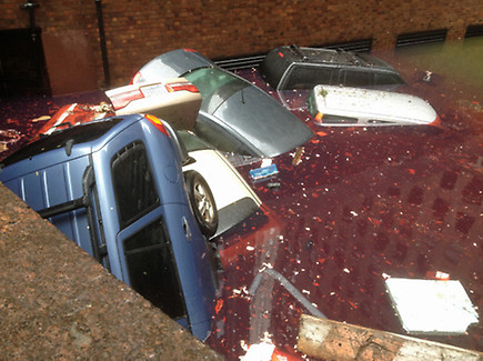
- A man in his 50s was found dead in a car in a flooded basement parking garage in Tribeca
Across the entire Northeast, the death toll from Hurricane Sandy currently stands at 39. Most of those people were killed by falling trees and/or tree limbs. Let's also not forget that 69 people were killed as a result of Sandy when the system traversed the Caribbean last week.
Our thoughts and prayers will certainly remain with the folks across the Northeast who are only just beginning to pick up the pieces after Hurricane Sandy.
Many people from around the world are visiting this blog to follow the aftermath of Hurricane Sandy. Please be sure to check the homepage of the blog and refresh there for all of the latest posts...
For more information from 'The Original Weather Blog', including shorter, more frequent posts during rapidly changing weather events, please be sure to follow Rob on facebook and twitter:
If you are in need of highly customized, site specific weather forecasts and/or storm warnings for your business, school or event, be sure visit my professional webpage at WeatherGuidance.com.
In a "quick update" post first thing this morning, I remarked that daylight was about to dawn on the aftermath of Sandy. As we all feared, it did not reveal a pretty sight. Here's is just a small sampling of the photos coming in from across the region:

Flooded Tunnel at Shore Parkway and East 7th NYC (NYPost)

Flooded Tunnel Beneath Battery Park (EPA)

View from the other side of Battery Park Tunnel (twitter)
Underground Garage in Manhattan (BBC)

Lobby of building on West St. NYC (Govs. Office)

Taxi Cab Lot in NYC (twitter/Jeremy Edouard)

Damaged Crane at One 57th St. (ABC)

Close Up View of the Crane Damage Above (ABC)

Hudson River on East 3rd St. NYC (twitter/ScottyB)

One of Many Broken Windows in NYC High Rises (twitter)

High Water at LaGuardia Airport (twitter/Nayab Ansari)

High Water at LaGuardia Airport (twitter/Jet Blue)

Tree Damage in Brooklyn (twitter/Alexander Hotz)

Water Main Break on Coney Island (twitter)

Breezy Point (Long Island) (AP)

Freeport (Long Island) (twitter/Patrick Whittle)

Street Adjacent to Atlantic City's Boardwalk (AP)

Atlantic City Street Turned into a Sandbar (ABC)

Before/After of Jersey Shore Coaster (RYOT News)
I will continue to pull aside some of the more telling photos and/or videos over the coming hours and days and will post them in additional updates.
Our thoughts and prayers will certainly remain with the folks across the Northeast who are only just beginning to pick up the pieces after Hurricane Sandy.
If you would like to help the folks in this region and are unable to do so physically, please consider making a donation to the American Red Cross or another reputable charity.
Many people from around the world are visiting this blog to follow the aftermath of Hurricane Sandy. Welcome visitors! Please be sure to check the homepage of the blog and refresh there for all of the latest posts...
For more information from 'The Original Weather Blog', including shorter, more frequent posts during rapidly changing weather events, please be sure to follow Rob on facebook and twitter:
If you are in need of highly customized, site specific weather forecasts and/or storm warnings for your business, school or event, be sure visit my professional webpage at WeatherGuidance.com.

One of the many tragedies of last night's impact from Sandy in the NYC area was on Breezy Point, located on the Western tip of Long Island, to the Southeast of Coney Island.
A house fire initially broke out around 11pm on Monday evening and spread quickly, engulfing over 50 (some reports indicate 80) homes before all was said and done.
All of this took place amidst incoming storm surge that made it very difficult for firefighters on the scene, not to mention nearly impossible for additional crews to arrive and help with the situation. FDNY says that several fire hydrants in the area were completely submerged in seawater, and it was difficult to get equipment where it needed to be.
The following video from the AP is very dramatic and unedited. Use caution when viewing around younger children (not a language issue, but a very dramatic scene of entire blocks of a residential area going up in flames:
Amazingly, and thankfully, I have not heard of any casualties directly related to this fire. I hope that the light of day today does not change that statistic. This area was 100% within the mandatory evacuation zone, so it is my hope that everyone got out on Sunday when told to do so.
It is unknown exactly how the fire began. This "island jetty" community took a direct hit by storm surge, high incoming wave action and strong winds. It is not uncommon for gas mains to become compromised in such a situation, which can lead to explosions if an ignition source comes into play. We've also see photos and videos all over NYC of transformers exploding and bursting into flames, which could have also played a role.
If you are interested in this particular part of the aftermath of Sandy, please bookmark this post and check back for updates. Also, please be sure to check the homepage of the blog and refresh there for all of the latest posts...
For more information from 'The Original Weather Blog', including shorter, more frequent posts during rapidly changing weather events, please be sure to follow Rob on facebook and twitter:
If you are in need of highly customized, site specific weather forecasts and/or storm warnings for your business, school or event, be sure visit my professional webpage at WeatherGuidance.com.

As we await sunrise across NYC and the Northeast, here are some up to the minute things that we do know in the aftermath of Sandy:
-Nearly 8 million people are without power across the Northeast, and that number continues to rise. This includes hundreds of thousands of customers in the ConEd service area (serving much of NYC):

-The tidal flood gauge at The Battery in NYC fell below flood stage during the pre-dawn hours, but is about to rise above it again as the morning tide rolls in. The peak water height is expected to reach 8 feet this morning:

-The New York City subway and mass transit system has suffered the greatest damage in its 100 year history. Water has to be pumped out of many subway and traffic tunnels before the full scope of the damage can be assessed. Only after that time will we know when service will be fully restored:


-Widespread tree limb, powerline and structural damage remains across the city. Do not venture outside until officials in your area have deemed it safe to do so. When you do venture out, please use extreme caution. Never cross a water covered roadway, and treat any downed power lines as if they are live.
-Outside NYC, a levee has been breached in Moonachie, New Jersey, along the Hackensack River. Evacuations are under way as waters rise.
This is just a brief snapshot of some of the major impacts that continue to plague the area in the aftermath of Sandy. Please check back throughout the day for frequent updates. Also please follow me on facebook and twitter for relevant updates throughout the day.
Our thoughts and prayers continue to be with the folks in this region...
As you might imagine, we are seeing lots of new visitor traffic here on the blog in dealing with the aftermath of Sandy. Welcome visitors! Unless the tag line at the end of a post indicates otherwise, please don't bookmark a particular post for updates, as new posts will be made each time we have new information to pass along. Please be sure to check the homepage of the blog and refresh there for the latest posts...
For more information from 'The Original Weather Blog', including shorter, more frequent posts during rapidly changing weather events, please be sure to follow Rob on facebook and twitter:
If you are in need of customized, site specific weather forecasts or storm warnings for your company or event, be sure visit Rob's professional webpage at WeatherGuidance.com.
Subscribe to:
Comments (Atom)


