Unfortunately as expected, thunderstorms are increasing across southeast Texas and Louisiana at this hour. This is a trend that will continue throughout the day, while shifting East/Northeastward.
A Severe Thunderstorm Watch is in effect until 4pm for east-central Texas and northwest Louisiana:
...and a Tornado Watch is in effect until 1pm CST for southeastern Louisiana:
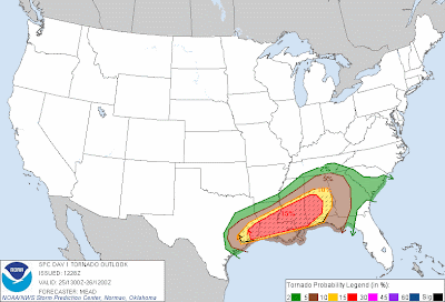
Many more watches, mostly Tornado, will be forthcoming today, so please stay weather aware if you live or will be traveling into the region. The latest severe weather outlook for today from the Storm Prediction Center (SPC) in Norman, OK is shown below:
Severe thunderstorms are likely anywhere within the yellow shaded area, with an elevated risk of particularly significant severe weather within the red shaded area.
As the morning hours pass, the tornado threat will increase and continue into this afternoon and evening. There is a high likelihood of strong and/or long track tornadoes, especially within the red shaded and black hatched area on the image below:
Damaging straight line wind gusts and large hail, some perhaps in excess of 2 inches in diameter, are also pronounced threats across this region.
If you will be within or near the severe weather threat areas this Christmas Day, please make sure to have a way of receiving severe weather warnings. Also take a few moments to determine your best sheltering option, especially if in an unfamiliar place. That way you can move there quickly if threatening weather is observed or a warning is issued.
For more information from 'The Original Weather Blog', including shorter, more frequent posts during rapidly changing weather events, please be sure to follow me on facebook and twitter:
If you are in need of highly customized, site specific weather forecasts and/or storm warnings for your business, school or event, be sure visit my professional webpage at WeatherGuidance.com.


0 comments:
Post a Comment