In today's episode of "Where's Waldo: Cold Front Edition" I give you the above Wind Chill and Heat Index map showing current conditions across the great state of Oklahoma...
That sharp contrast in temperature will focus strong to severe thunderstorm development this afternoon and evening. I still feel that southwest through central Oklahoma will have the highest threat of very large hail and a few tornadoes, with wind damage and some hail the primary threat further East this evening.
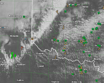
This close-up visible satellite image below shows clouds beginning to tower along the cold front from near Childress, TX up Northeast into southwestern Oklahoma at this hour:
All of the green and orange car symbols show the current location of storm chasers that are converging into the area in anticipation of the afternoon's developments.
Stay tuned, it's liable to get pretty wild a bit later this afternoon...
If you live or have travel plans across the area this afternoon or evening, please be sure to stay alert and make sure that you have a way to receive severe weather warnings - no matter what time of day it is or where you might be.
For more information from 'The Original Weather Blog', including shorter, more frequent posts during rapidly changing weather events, please be sure to follow me on facebook and twitter:
Coming April, 2013: "The Tornado Chronicles" full website!
• Interactive tornado database back to 1950 (earlier years coming soon)
• Interactive radar with live warnings and street-level zoom
• Tornado safety, preparedness and education
• Daily tornado/severe weather outlook
• Photos, videos and more!
Please show your support and follow The Tornado Chronicles on twitter and on facebook for the latest updates on tornadoes and the upcoming website!


0 comments:
Post a Comment