After a (thankfully) relatively quiet period with only isolated to scattered severe weather events on Saturday and Sunday, it looks like we're going to be lunged back into a more active pattern for this week...especially the first half of the week.
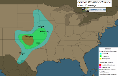
Below are the severe weather outlooks for today through Wednesday, respectively:
Right now, it appears that the most active day will likely be tomorrow, Tuesday, as the combination of middle and upper level jet stream winds and Southerly low level winds will be strongest during the afternoon and evening hours across portions of the central and southern High Plains. This type of set up is likely to produce some of the more organized storms of the week, with the potential for very large hail and tornadoes with the strongest storms.
Otherwise, there will be a risk for damaging winds, large hail and a few tornadoes with severe storms today through Wednesday, with the highest risk located within the green and reddish-orange shaded areas on the above images.
The threat of severe weather will shift East/Southeast into portions of the Mississippi, Ohio and Tennessee Valley Regions on Thursday and/or Friday, but at this time there is too much uncertainty regarding the placement of low level boundaries to focus in on a particular area for an elevated threat. Stay tuned for updates on that as we move through the week.
If you live or have travel plans across the severe weather threat areas, please stay alert, particularly during the afternoon and evening hours. Make sure you have a plan in place ahead of time so that you can quickly get to shelter if threatening weather is observed or a warning is issued.
For more information from 'The Original Weather Blog', including shorter, more frequent posts during rapidly changing weather events, please be sure to follow me on facebook and twitter:


0 comments:
Post a Comment