The National Weather Service (NWS) storm survey team has determined that 5 tornadoes touched down across Prowers, Bent and Kiowa Counties in southeast Colorado during the early morning hours (between 1:49 and about 2:40 a.m. MDT) of April 27, 2012.
One tornado touched down just to the Southwest of the city of Lamar. This tornado was rated EF-2 intensity by the NWS survey team, with maximum winds estimated near 115 mph.
The photo above is an aerial image showing damage to a large hog farm in the area. Fortunately, the three little pigs weren't at home when the big bad wolf blew their house down. (Sorry, I couldn't resist that one - but seriously, no pigs were killed or injured as the 18 barns that were destroyed were unoccupied at the time).
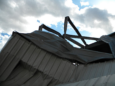
The photos below (by the NWS survey team) show the damage to the hog farm up close:
A second tornado touched down East of Lamar, with a 12 mile path length. It too was estimated at EF-2 intensity, with maximum winds of up to 115 mph. The survey notes that 4 homes were heavily damaged or destroyed, and 6 people were injured. There was also significant damage done to a communications tower:
A third tornado touched down near Chivington, causing EF-1 intensity damage to a mobile home where 1 person was injured:
A fourth tornado touched down about 3 miles Northeast of Chivington, causing damage to mobile homes and ranch buildings. Damage was estimated at EF-2 intensity.
The survey on this tornado describes a mobile home that was lofted approximately 30 feet and then "wrapped around a truck" when returning back to the ground. I believe the photos below (via the Department of Emergency Management) show that scene:
A fifth tornado took place across extreme northeastern Bent County, to the North of US Highway 50. It was estimated to have been 250 yards wide at its peak, with an intensity rating of EF-2:
This tornado caused a cornstalk to become embedded in a crack on a telephone pole:
I will post additional information, including track data and photos and/or videos pertaining to this event as soon as they become available.
For more information, including "live blogging" during rapidly changing weather events, please be sure to follow me on facebook and/or twitter:


0 comments:
Post a Comment