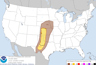
As mentioned in a post on Monday, there will be an increasing risk of severe thunderstorm and tornado development across the central and southern Plains during the second half of this week. Below are the latest severe weather outlooks for Thursday, Friday and Saturday (respectively) from the Storm Prediction Center in Norman, OK:
Severe Weather Threat Thursday (Yellow Shaded Area)
Severe Weather Threat Friday (Yellow Shaded Area)
Severe Weather Threat Saturday (Red Shaded Area)
Very large hail, damaging thunderstorm winds and tornadoes will be possible in the severe weather threat areas each day.
At this time, it appears that the highest threat for potentially significant tornado development will take place on both Friday and Saturday from southcentral and southeast Nebraska, Southward across central and eastern Kansas and much of Oklahoma.
The primary severe weather threat will take place during the traditional late afternoon and evening hours in most areas, however some potential does exist for activity to continue into the nighttime hours on both Friday and Saturday night's.
Folks living across the above mentioned areas should make plans now to monitor local weather conditions on the indicated days. Take the time to review severe weather and safety preparedness information, and be ready to seek shelter immediately if threatening weather approaches your area.
The threat of severe weather will not end on Saturday. It will continue into Sunday and Monday, while generally shifting to the South and East as well. More to come on those specific details in later updates...
If you enjoy reading the blog, please click on the icons below to "Like" my facebook page and/or follow me on twitter. You'll find posts at these locations that aren't always on the blog, especially during rapidly changing weather situations...


0 comments:
Post a Comment