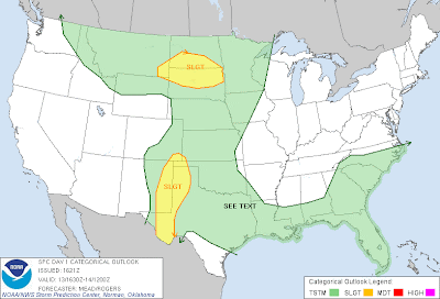
Severe thunderstorms are forecast on the High Plains of West Texas and Eastern New Mexico again today, as well as in parts of the Dakotas.
The areas shaded in yellow on the above image have the greatest risk of severe weather, most of which will consist of large hail and damaging winds. A few isolated tornadoes are also possible, particularly during the first few hours of thunderstorm generation later this afternoon and this evening.
If you live in or near these areas, please remain alert and be prepared to seek shelter if threatening weather is observed or a warning is issued for your area.
For more information, including "live blogging" during rapidly changing weather events, please be sure to follow me on facebook and/or twitter:


0 comments:
Post a Comment