Above is the latest visible satellite image showing a broad area of disturbed weather in the southeast Gulf of Mexico. The actual surface circulation center appears to be just to the Northwest of the tip of the Yucatan Peninsula, and is forecast to be located near the red "L" in the following image at 7pm CDT this evening:
Little has changed since yesterday, insofar as the possible eventual tracks of this system. It was very disappointing to hear that NOAA cancelled the Air Force Hurricane Hunter flight that was scheduled for this afternoon, as it would have given valuable data regarding the developmental stages of this system, which would have then been fed into the computer models for greater clarity. They are promising such a mission tomorrow, and hopefully it will come to pass this time.
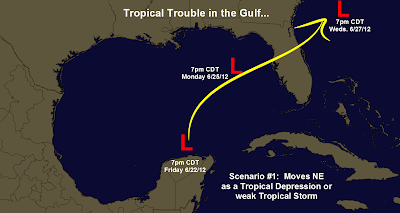
The majority of the computer forecast models are in two camps, just like they were yesterday. The first scenario takes the system Northeastward across Florida early next week as a Tropical Depression or Tropical Storm (which would be called "Debby"):
The second scenario would take the system on more of a Northwestward then Westward track, possibly impacting the Lone Star State by mid to late week next week. Under this scenario, the system would have plenty of time to organize into a Hurricane ("Debby"):
At this point in time, I am still of the opinion (as I was yesterday) that the system will most likely track along or near the path outlined in scenario #1, with Florida most likely to be impacted early next week. There are two main reasons that I continue to feel this way:
(1). A broad trough of low pressure is forecast to develop across the Eastern third of the U.S. this weekend. The influence of this trough on the steering flow would tend to draw the tropical cyclone up into it, turning it more toward the East and then Northeast.
(2). It is very unusual for a tropical cyclone to turn toward the West after it has moved North of 25 degrees North Latitude during the month of June (not during the other months of hurricane season - just June). Since 1900 this has happened only 1 time, in association with Hurricane Bonnie in 1986. That was a very unusual situation where the system came under the influence of a surface boundary that forced it to turn Westward. There is no such boundary present under the particular situation that we're dealing with now.
For the record, there are also computer model solutions that call for a landfall anywhere in between the above tracks, from Texas to Florida, all along the Gulf Coast. The majority of the models come to one of the two scenarios outlined above (not quite a 50/50 split, about 60/40, with the Florida solution carrying the higher odds).
This situation will become much clearer as the system continues to organize over the weekend. If an Air Force mission is completed in the system tomorrow, valuable data will be fed into computer models tomorrow night that would also lead to greater clarity and consensus as well.
As I mentioned yesterday, regardless of the eventual track of this system, folks in Florida can expect widespread, heavy rainfall over the weekend. Rainfall totals may exceed 6 inches in some areas:
Coastal surf will also be on the increase across the northeast and east-central Gulf over the weekend, producing dangerous rip currents in some areas.
On the weather trivia side of things, if in fact we do get a storm named Debby this weekend (or early next week), this will be the only time since record keeping began (in 1851) that we will have had 4 named storms in the Atlantic Basin by the end of June.
Stay tuned, as much more is to come over the weekend. For additional details including the latest satellite and radar imagery and loops of this system, please visit this dedicated page on our sister site, WeatherGuidance.com.
For more information, including "live blogging" during rapidly changing weather events, please be sure to follow me on facebook and/or twitter:


0 comments:
Post a Comment