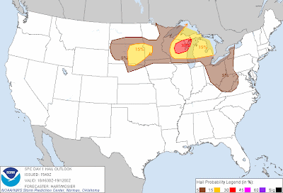
Severe thunderstorms are forecast across an area from the northern Plains into the Western and Central Great Lakes region this afternoon and into tonight. Specifically, severe storms are forecast within the yellow shaded areas on the above image, with an elevated risk of large hail and damaging winds within the red shaded area on the same image. Strong to locally severe storms are possible within the larger, brown shaded area.
Thunderstorms are forecast to develop and/or increase in areal coverage and intensity this afternoon and evening across central and northern Wisconsin. This activity will move and/or develop Eastward throughout the severe weather risk area into the evening and at least early tonight. Large hail, damaging wind gusts and a few tornadoes are possible in this region.
Other thunderstorm activity is forecast to develop and/or increase during the afternoon and at least early this evening over the Ohio Valley region (generally within the brown shaded area in that region on the above map). While widespread severe weather is not forecast in this area, a few of the storms could become locally severe with large hail and strong wind gusts.
Later this evening and into tonight, thunderstorms are forecast to develop as moist, unstable air returns Northward into eastern South Dakota and extreme northcentral/northeast Nebraska. Despite the fact that this development will occur after sunset and into the overnight hours, some of the stronger storms will have the potential to produce large hail.
If you live across any of the above mentioned areas, be sure to listen to NOAA Weather Radio, local media or another trusted source for later statements and possible warnings.
For more information, including "live blogging" during rapidly changing weather events, please be sure to follow me on facebook and/or twitter:


0 comments:
Post a Comment