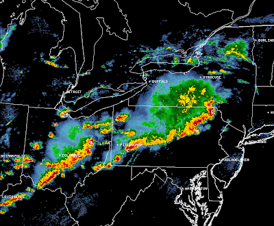
The latest radar mosaic image above shows several lines of strong to severe thunderstorms across the Ohio Valley and Northeast. The most severe activity at this time extends along the two main lines, dissecting Pennsylvania from Northeast to Southwest, and across central and southern Ohio.
Damaging straight line wind gusts are the primary threat in this region along and ahead of these storms, although some brief tornado spin-ups are possible with some of the more organized embedded storms. Such storms are currently located over northeast Pennsylvania to either side of the Wilkes-Barre / Scranton areas.
A Tornado Watch is in effect for this region until 9pm EDT, as shown in red on the image below. Severe Thunderstorm Watches continue throughout the evening for the areas noted in blue on the same image:
In this type of situation, the highest tornado potential is along the rotating comma heads associated with bands or short lines of thunderstorms that produce strong, damaging wind gusts. This type of tornado activity tends to be short lived, however if you happen to be unlucky enough to be in the path of one, it really makes no difference how long lived it is when its causing damage to your property. The other bad thing about this type of tornado is that they tend to develop quickly and dissipate just as quickly, not allowing much time for radar detection (if any).
Here is an example showing the two storms that I referenced above to either side of the Wilkes-Barre / Scranton, PA areas. The tornado warning areas shown in lavender, and you can see that they coincide with the location of enhanced signatures on radar near the bowing or "dog leg" segments of the line:
Thus far, no actual ground reports of tornadoes have been received with this activity, but that certainly does not mean that it hasn't happened or will not happen in the near term.
In this type of situation, damaging wind gusts may exceed 70 mph with severe storms across the Tornado and Severe Thunderstorm Watch areas this evening. With that in mind, I highly suggest that folks in the path of these storms seek shelter as if there was a tornado, that way you are protected from both the potentially strong, damaging winds, as well as any brief tornadoes that may in fact spin up if you are in an area favored for such development.
Large hail is also possible, which can cause additional heavy damage when driven by strong wind gusts.
Based on the present location and movement of this activity, a threat of widespread severe weather will spread into the Philadelphia and New York City Metro areas by 7 to 8 o'clock this evening. This timing could come an hour or so early if the storms suddenly gain forward speed over the next hour (which is possible as they intensify and produce strong outflow winds).
If you live across the region ahead of these storms, pay attention to the weather this evening and be prepared to move to shelter immediately if threatening conditions are observed or a warning is issued for your area.
For more information from the Original Weather Blog, including "live blogging" during rapidly changing weather events, please be sure to follow me on facebook and/or twitter:


0 comments:
Post a Comment