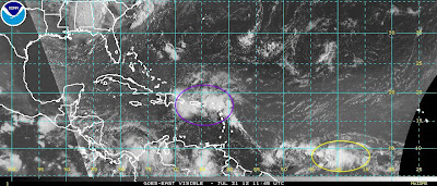
After a long period of quiet weather to start the hurricane season in the Atlantic Basin, there are currently two active tropical waves across the region this morning.
The first, circled in purple on the above satellite image, will produce widespread heavy rain across Puerto Rico, the Virgin Islands and other adjacent portions of the Caribbean for the next 24-48 hours. Flash flooding and mudslides are possible, along with gusty winds. This system is not expected to mature into a named storm or hurricane the way it looks right now. Moisture from this system will begin to impact Florida late this week and into this weekend.
The second disturbance, shown in the yellow circled area, bears watching as it tracks slowly toward the West and eventually the West/Northwest over the next few days. There are indications that it could become Tropical Storm Ernesto by the end of the week as it tracks toward the Lesser Antilles, and will need to be closely monitored as it moves West/Northwest from there toward the Caribbean Sea later in the weekend.
For more information from the Original Weather Blog, including "live blogging" during rapidly changing weather events, please be sure to follow me on facebook and/or twitter:


0 comments:
Post a Comment