The Original Weather Blog: New York MTA Map of Subway Lines

  • Subscribe to our RSS feed.
  • Twitter
  • StumbleUpon
  • Reddit
  • Facebook
  • Digg

Sunday, 29 July 2012

Tornado Near Mt. Evans, CO on 7/28/12 a New Record High Elevation?

Posted on 06:36 by shohan bella


A tornado touched down close to Lincoln Lake near Mt. Evans, CO on Saturday afternoon, July 28, 2012. Mt. Evans is located in the Arapaho National Forest and is about halfway between Breckenridge and Denver.  The elevation at the summit is 12,500 feet above sea level.


The following photo was posted on twitter by John Hallan, but it does not say who shot the photo.  The tornado was quite picturesque, and looks somewhat like a waterspout in the photo:


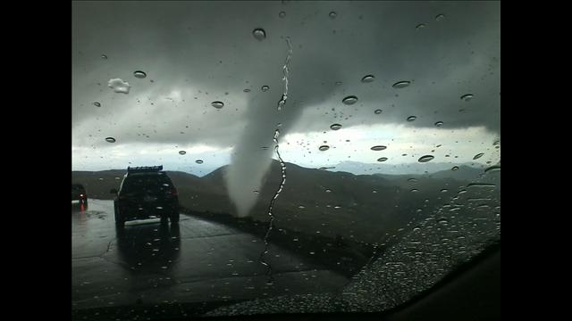
Here's another photo, this one taken by Trish and Dan Ferguson:


...and another by Karen Goodwin:


Some additional photos of the tornado, taken by Chris Kirby (and at a much closer vantage point), can be found on his flickr stream.  On a related twitter post, he commented that the outside temperature was 40 degrees F at the time the tornado took place.


The preliminary local storm report for this event is shown below:


While the storm report doesn't hint at this, if the 12,500 foot elevation stands, I believe that the tornado will go down in the record books as the highest known elevation tornado in the U.S.  The previous highest elevation tornado took place at Rockwell Pass, California on July 7, 2004.  The elevation of the pass is 11,600 feet, and it is estimated that the base of the tornado was at approximately 12,000 feet.


If the 12,500 foot elevation of yesterday's Mt. Evans tornado stands, then it should take the record.  I'm awaiting "official" comment from the National Weather Service (NWS) in Boulder, and will post that as soon as it becomes available.


***Update 7/29/12, 5pm:  The NWS in Boulder has not issued a revised or updated storm report or "public information statement" on the tornado, however a recent posting on their facebook page states that they used the photographer's position and extrapolated via Google Earth that the elevation of the base of the tornado was approximately 11,900 feet.  This would make it 100 feet short of the old record referenced above.  So, at the moment, the Rockwell Pass tornado record stands.


I have some personal reservations about a 100 foot difference being calculated via Google Earth, but "it is what it is..." I suppose.  I don't know exactly how the Rockwell Pass elevation was calculated back in 2004, as the available documentation states that they "estimated that the base of the tornado was at approximately 12,000 feet" so I think its safe to say both of these tornadoes were very, very close to one another insofar as elevation is concerned.


For more information from the Original Weather Blog, including "live blogging" during rapidly changing weather events, please be sure to follow me on facebook and/or twitter:


Email ThisBlogThis!Share to XShare to Facebook
Posted in 2012 Tornado Chronicles, Tornadoes, Weather Records | No comments
Newer Post Older Post Home

0 comments:

Post a Comment

Subscribe to: Post Comments (Atom)

Popular Posts

  • Tornado Strikes Sasolburg, South Africa; 1 Dead, Over 100 Injured...
    An apparent tornado struck Sasolburg, Free State in South Africa before dawn today (U.S. time).  According to media reports, an elderly woma...
  • Are Computer Models Getting Better with Snow Forecasts?
    I've been tweeting off and on for the last few days about the upcoming snow event for Chicago this morning (photo above courtesy CBS Chi...
  • The Tornado Chronicles: Kanopolis Lake and Salina, KS Area Tornadoes of 4-14-12...
    A single supercell thunderstorm produced at least 3 tornadoes across central Kansas during the afternoon and evening hours of Saturday, Apri...
  • Sandy's Fallout Continues: Gas Rationing, Hospital Shortage In NYC...
    By now you've probably heard the news, gas will be rationed in NYC and on Long Island effective 6am EST tomorrow.   If your license plat...
  • Severe Weather Threat Deep South Today; 1 Tornado Already Reported...
    At least 1 tornado has already been reported in Louisiana this morning.  This is associated with the same storm system that affected Texas y...
  • Isaac Likely a Hurricane (or Very Close)...
    A mid-morning update is due out from the National Hurricane Center (NHC) at 10am CDT. I am not sure whether or not they will "pull the...
  • Tropical Storm Beryl Pounding South Georgia and North Florida...
    The above image was just taken from the Valdosta, GA area doppler radar site. You can see the center of Tropical Storm Beryl located 15 or s...
  • A Week Full of Hail: Storms Pound New York State, Vermont, Oklahoma City and Wichita...
    Giant hailstones ravaged the country during the last week of May 2012. I'm not just talking about "the usual suspects" in the ...
  • Former Tropical Depression Alberto Continues to Diminish...
    Tropical Depression Alberto continues to weaken and is no longer considered tropical.  Advisories are no longer being issued on the system, ...
  • HRRR Computer Model No Longer "Experimental" As of Today...
    Regular readers of the blog will recognize an image like the one above. It's a computer forecast model representation of what the radar ...

Categories

  • 2011 Drought
  • 2012 Drought
  • 2012 Fall and Winter Outlook
  • 2012 Tornado Chronicles
  • 2012 Transit of Venus
  • 2012 Tropical Weather - Atlantic
  • 2012 Tropical Weather - Pacific
  • 2012 Year In Review
  • 2012-2013 Drought
  • 2013 Tornado Chronicles
  • Arizona Wildfires
  • Astronomy
  • aviation weather
  • Billion Dollar Disasters
  • Blizzard of 2013
  • Blog Status
  • Book Reviews
  • Central U.S. Weather
  • Chicago Weather
  • Christmas 2012
  • Circuit of the Americas
  • Climatology
  • Computer Models
  • Deep South Weather
  • Derechos
  • DFW Weather
  • Drought
  • Earthquakes
  • Eclipse 2012
  • Eclipse 2017
  • El Nino
  • Event Summaries
  • Excessive Heat
  • Extreme Weather
  • Flooding
  • General Blog Info.
  • Gulf Coast Weather
  • Happy Easter
  • Happy New Year
  • Holiday Travel Weather
  • Holidays
  • Hurricane Carlotta
  • Hurricane Hugo
  • Hurricane Isaac
  • Hurricane Sandy
  • Illinois Weather
  • International Events
  • International Weather
  • Italy
  • Joplin Tornado
  • KY Weather
  • Lightning Safety
  • Long Range Outlook
  • Medium Range Outlook
  • Mid-Atlantic Weather
  • Midwest Weather
  • MS Valley Weather
  • National Weather Service
  • Northeast Weather
  • Northern Plains Weather
  • Ohio Valley Weather
  • Oklahoma Tornadoes
  • Oklahoma Wildfires
  • Perseid Meteor Shower
  • Radar
  • Rainfall Update
  • Record Events
  • Registered Members
  • Satellite Imagery
  • Seasons
  • Sev
  • Severe Local Storms
  • Severe Weather Outlook
  • Severe Weather Update
  • Severe Weather Update - TX
  • Severe Weather Update - TX OK KS
  • Severe Weather Outlook
  • Severe Weather Safety and Preparedness
  • Severe Weather Update
  • Sheltering eBook
  • Shelters
  • social media
  • Southeast U.S. Weather
  • Southern Plains Weather
  • Southern Snowfall
  • Space Weather
  • Storm Chasing
  • Tennessee Valley Weather
  • Texas Weather
  • Thanksgiving 2012
  • Tornado History
  • Tornado Outbreaks
  • Tornado Video
  • Tornado Videos
  • Tornadoes
  • Tropical Depression 2-E
  • Tropical Depression 4-E
  • Tropical Storm Alberto
  • Tropical Storm Beryl
  • Tropical Storm Bud
  • Tropical Storm Carlotta
  • Tropical Storm Debby
  • Tropical Storm Helene
  • Tropical Storm Isaac
  • Tropical Weather
  • Tropical Weather 2012 - Atlantic
  • Tropical Weather 2013
  • Tsunamis
  • Typhoon Sanba
  • weather disasters
  • Weather History
  • Weather Humor
  • Weather In the News
  • Weather Photography
  • Weather Prediction
  • Weather Records
  • Weather Technology
  • Weather Trivia
  • West Liberty
  • Western U.S. Weather
  • White Christmas 2012
  • Winter 2012-2013
  • Winter 2013-2014
  • Winter Weather 2012
  • Winter Weather 2013-2014

Blog Archive

  • ►  2013 (158)
    • ►  December (1)
    • ►  November (3)
    • ►  October (2)
    • ►  September (8)
    • ►  August (4)
    • ►  July (10)
    • ►  June (7)
    • ►  May (20)
    • ►  April (20)
    • ►  March (20)
    • ►  February (29)
    • ►  January (34)
  • ▼  2012 (342)
    • ►  December (48)
    • ►  November (37)
    • ►  October (46)
    • ►  September (21)
    • ►  August (33)
    • ▼  July (16)
      • Highest Temperature on Record for Oklahoma In Jeop...
      • Tropical Atlantic Showing Some Signs of Life...
      • Unusually Large Hail Fell on Parts of Italy Yester...
      • Tornado Near Mt. Evans, CO on 7/28/12 a New Record...
      • The Tornado Chronicles: Elmira, NY Tornado of 7-2...
      • "Tornado Drought" Continues Despite Yesterday's Ac...
      • Severe Weather Update - OH Valley / Northeast
      • Widespread Severe Weather Likely From OH Valley In...
      • Update on Severe Weather Threat for Thursday...
      • Tornado "Drought" Continues Across U.S. - Going Cr...
      • Widespread Severe Weather Likely Tomorrow Ohio Val...
      • Book Review: "Joplin: The Miracle of the Human S...
      • One or More Tornadoes Struck Poland on Saturday Ev...
      • Widespread Severe Weather Likely Mid-Atlantic / De...
      • Tropical Depression Forms in Pacific off of Mexica...
      • Quiet Start to July in the Tropical Atlantic...
    • ►  June (36)
    • ►  May (50)
    • ►  April (55)
Powered by Blogger.

About Me

shohan bella
View my complete profile