The latest composite satellite and radar imagery (shown above) indicates that the winter storm system is progressing as planned, and folks across the Northeast and especially New England are in for a crippling blizzard and/or snow storm over the next 24-36 hours.
The system currently consists of 2 pieces, as labelled on the image. The two are quite strong in and of themselves, and will wreak even more havoc once they merge across the Northeast later today and tonight.
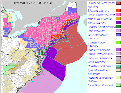
The latest advisory, watch and warning map from the National Weather Service (NWS) is shown below:
Blizzard Warnings are in effect in the areas shaded in orange, with Winter Storm Warnings in the areas shaded in pink. If you live in either of those areas, you should have already completed your preparations, as the weather will be going steadily downhill throughout the day today.
The latest run of the ECMWF model, which has been the most consistent with this storm throughout, continues to call for excessive snowfall amounts, especially in a band extending from Long Island to the Boston area through Saturday evening:
I know the model does not indicate it (scale in inches of snow on the right hand side of the image), but totals in excess of 36 inches are quite likely within the lighter/whitish pink areas in New England.
Couple the heavy snowfall with very strong and gusty winds, and and all out blizzard will result across much of this region, especially by this evening and into tonight. It will not be safe to be outdoors under these conditions.
A Hurricane Force Wind Warning continues offshore from Long Island all the way up through Maine, as winds will easily reach hurricane force once this storm gets wound up later today and tonight. As a result of the strong winds, extensive beach erosion and coastal flooding can be expected.
As we've been pointing out for the last few days, the greater Boston area will likely find itself in the bullseye of the worst of this storm, as far as the major cities go, as well as much of Connecticut and Rhode Island.
Most of the short range computer models continue to forecast upwards of 30 inches for the Boston area through 7pm EST on Saturday:
Most of the snow in the Boston area will fall from around rush hour today through Saturday morning. Combined with wind gusts that may reach 50-60 mph at times, an extremely dangerous situation will develop across the region very quickly, and travel is highly discouraged after 12 Noon today.
A bit further South, the New York City area is right on the pivot point between "heavy" snow and "excessive" snow. The latest run of the Short Range Ensemble Forecasting (SREF) models are calling for an average of 15 inches of snow at New York's LaGuardia airport through sunrise tomorrow:
That's an increase of 5 inches from the forecast by the same models at this time yesterday. As you can see, a rather wide range in forecast values continues at NYC, but the average of the "low end" numbers has increased to upwards of 10 inches since yesterday.
The exact track of the surface low later today and tonight holds the key as to exactly how much snow will fall in NYC, but based on current observations and the expected trends, I agree with a 10-15 inch forecast for most of the city. Folks should keep in mind, however, that any slight change in track would likely result in more snow for the city - not less, so I would plan accordingly. Blizzard conditions will also make matters even worse across the area later today and tonight.
I hope that everyone across the region has prepared for this storm, which is likely to go down in the record books for winter storms in many areas. Now that we're approaching the timeframe where this event will actual begin to unfold, look for shorter posts (most likely on twitter and/or facebook) with any significant observations as they arise.
For more information from 'The Original Weather Blog', including shorter, more frequent posts during rapidly changing weather events, please be sure to follow me on facebook and twitter:
Coming March 2013: The Tornado Chronicles full website!
• Interactive tornado database back to 1950 (earlier years coming soon)
• Interactive radar with live warnings and street-level zoom
• Tornado safety, preparedness and education
• Daily tornado outlooks/threat index
• Photos, videos & more!
Please show your support and follow The Tornado Chronicles on twitter and on facebook for the latest updates on tornadoes and the upcoming website!


0 comments:
Post a Comment