Low level moisture is returning to southern and central Texas this morning, as noted by the dew point temperatures in the 50s (green) and 60s (yellow) on the latest surface map above. Southerly winds will continue to pull this moisture Northward into much of central and eastern Texas throughout the day today and into tonight.
Meanwhile, as you can see on the same image, very dry air is in place in west Texas and the Texas/Oklahoma panhandle region, resulting in the development of a fairly strong dryline from near the Texas/Okalhoma border in the Texas panhandle, Southward into west-central Texas.
Increasing instability in the middle and upper levels of the atmosphere will gradually move out over the western High Plains later this afternoon and into this evening, likely resulting in scattered thunderstorm development along the dryline.
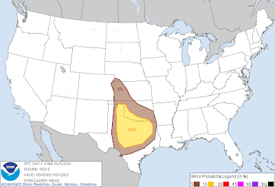
Some of these storms may become severe, with large hail and damaging wind gusts the primary threat (although a few isolated tornadoes are possible) as noted by the latest severe weather outlook from the Storm Prediction Center (SPC) in Norman, OK:
Severe storms are possible within the brown and yellow shaded areas on the image. As described above, the initial threat will exist in far West Texas and the Texas/Oklahoma panhandle region late this afternoon and into this evening.
Overnight tonight, a threat for more widespread thunderstorm development will exist across central and eastern portions of the outlook area, as upper level energy increases and the surface dryline and a Pacific cold front move East/Southeast across the region.
The potential exists for a fairly extensive squall line to develop along the surface boundaries across central and northern Texas, into the Red River region with Oklahoma after 12 Midnight tonight, into the pre-dawn hours on Sunday. Damaging wind gusts and some spotty hail will be the primary threats at that time, and includes the Dallas/Ft. Worth Metroplex region.
If you live across the above mentioned areas, please remain alert later this afternoon, this evening and especially tonight. If you live in central and eastern portions of the severe weather outlook area, be sure that you have a way to receive severe weather warnings overnight tonight.
The threat of strong to severe thunderstorm activity will shift East/Southeast into the lower Mississippi Valley region on Sunday, as indicated by the severe weather outlook below:
Here again, damaging wind gusts and some marginally severe hail will be the primary severe weather threats on Sunday. Strong to severe storms will likely be ongoing around sunrise Sunday near the Western edge of the outlook area, with the activity expected to progress Eastward during the day.
A few tornadoes will be possible on Sunday, particularly with any storms that are able to form out ahead of the main line and become well organized.
For more information from 'The Original Weather Blog', including shorter, more frequent posts during rapidly changing weather events, please be sure to follow me on facebook and twitter:
Coming March 2013: The Tornado Chronicles full website!
• Interactive tornado database back to 1950 (earlier years coming soon)
• Interactive radar with live warnings and street-level zoom
• Tornado safety, preparedness and education
• Daily tornado outlooks/threat index
• Photos, videos & more!
Please show your support and follow The Tornado Chronicles on twitter and on facebook for the latest updates on tornadoes and the upcoming website!


0 comments:
Post a Comment