As of the 10pm CDT advisory, the National Hurricane Center (NHC) continues to hold-off on declaring Isaac a hurricane. As stated in earlier posts, I believe that Isaac has been a hurricane since midday today (based on satellite, ship and some aircraft observations), but that's neither here nor there at this point, especially since I am not a NHC employee. I am just hoping that those awaiting an "official" declaration from the NHC before taking action don't wait until its too late to move out of harms way. My reasoning for this will be detailed a bit further below...
As far as the particulars are concerned... at 10pm CDT, the center of Isaac was located about 190 miles Southeast of the mouth of the Mississippi River. Maximum sustained winds were estimated at 70 mph by the NHC, and the minimum central barometric pressure was 28.91 inches of mercury. Isaac is currently moving toward the Northwest at about 10 mph.
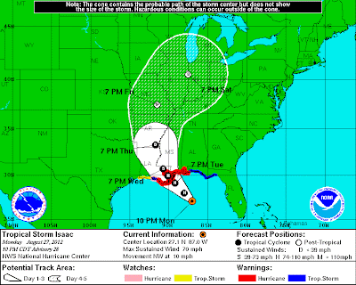
Isaac will continue strengthening tonight and Tuesday as the center becomes better organized and continues to move over very warm Gulf waters. It is still possible that Isaac will become a "major" hurricane prior to landfall. The latest NHC track is shown below. While I don't necessarily agree with their intensity forecast, I do generally agree with their track forecast as far as the center of Isaac is concerned. With that said, please remember that it's important not to focus solely on the location of the center, as tropical storm and hurricane conditions will be felt well away from that point, especially on the right (Eastern) half of the system:
Regardless as to whether or not Isaac reaches "major" hurricane status with respect to wind speed, perhaps the most dangerous threat will be that of storm surge and related flooding. Isaac is moving and will continue to move at a slow pace, much slower than Katrina did in 2005. This will lead to an extended period of dangerous, potentially life threatening storm surge flooding across a large part of the southeast Louisiana coast, as well as portions of the Mississippi coast:
In addition to the storm surge, and to further aggravate matters, flooding rainfall in excess of 10-15 inches will be likely across a widespread area:
The angle at which Isaac is forecast to come in will result in literally tons of water being pushed up into southeast Louisiana, for an extended period of time substantially longer than during Katrina in 2005. While I sincerely hope that the new and improved levee system will hold, I continue to strongly suggest that anyone in a flood and/or storm surge flood prone area move to higher ground before Noon on Tuesday (and tonight if at all possible, to avoid the rush that is likely to ensue on Tuesday).
Regardless of whether or not Isaac reaches "major" hurricane strength, strong, damaging straight line winds of at least Category 1 hurricane force with higher gusts can also be expected for an extended period of time across southeast Louisiana and southern portions of Mississippi and Alabama. Such conditions will begin on Tuesday afternoon and continue in some areas through Wednesday morning or midday.
Folks across this region have hopefully completed their hurricane preparations today. If you are still in the area and have been debating whether or not to move inland, I strongly suggest that you do so. Several computer models suggest that rapid intensification is likely prior to landfall on Tuesday, including when Isaac is just a few hours from striking (with respect to the center making landfall). Conditions are likely to become very bad or worse before you have time to react, so please take the "better safe than sorry" approach.
For the latest imagery and updates on Isaac, please refer to this dedicated webpage at our sister site, WeatherGuidance.com. In addition to more frequent posts here on the blog on Tuesday and Wednesday, I will also post various shorter updates with additional images, etc., on both facebook and twitter. If you would like to receive those updates, please be sure to follow me there if you aren't already:


0 comments:
Post a Comment